In honor of World Car-Free Day, more from Andy Singer:
Why busing beats driving, according to my Gail:
1) You don’t have to wait for a light to put on your makeup!
2) You don’t get accused of causing accidents just because your cell phone rings or you have to kill a bee!
3) If someone scratches the bus you don’t have to lose a day’s work getting quotes! Likewise,
4) If your fellow passenger throws up – no one has to fight over who’s going to clean it up!
5) On rainy days you don’t have to carry extra mats for the floor!
6) You don’t burn your be-hind on the seats on hot summer days.
7) You never hear of small children being left on a running bus for ‘just a second’ when Mom jumps off at a 7-eleven for a Slurpy.
Most of you know that I think Seattle has a great bus system. Buses here work for me because:
1) I have spent time learning the routes I use regularly, and
2) I do advance research to figure out how to get places I’ve never been before.
Buses here don’t necessarily work for:
1) Tourists.
2) People like Jonathan Kauffman, Seattle Weekly writer and newbie Seattleite. (Brad from First Hill, a former newbie Seattleite, sent me this essay Jonathan wrote about Seattle’s buses.)
Jonathan thinks Metro should have a comprehensive system map that is easily available at major bus stops.
But every time I want to get on a bus, I have to call Mama Metro to tell me which one to take–there’s no way for me to get to know the city on my own terms or my own time. All I need, I’ve been telling anyone who dares offer help to a guy staring up at a bus stop with bewilderment and rage on his face, is a good map: just a street map of Seattle with the bus lines printed on them. That’s it. Portland, Vancouver, and New York have them. You can pick up a street/bus map at every El stop in Chicago or find one posted at every major bus stop in San Francisco. Never felt lost in those cities.
I do, too.
Metro’s current system map is reasonably useful for figuring out which routes go to which parts of the city, but it’s not easily available, and it doesn’t include most street names (key for effective navigation).
What do you guys think? Does Metro need a more extensive system map, or are you happy with Trip Planner and the maps at stops and in schedules?
Real Change recently interviewed Anthony Flint, author of This Land: The Battle over Sprawl and the Future of America. Here are some excerpts from the discussion:
Real Change: What are the effects of sprawl on the environment?
Anthony Flint:
Twenty-five million acres of land between 1982 and 1997 succumbed to suburban development. That is a lot of wildlife habitat [and] farmland that has disappeared. It is a lot of pollution from cars, which are necessary to get around in these dispersed environments, though it has not been enough to change anybody’s mind about sprawl until now. On a personal level, people are discovering that it is inconvenient and actually very expensive to live in sprawl.RC: …some commentators have said that sprawl is a sign of a good economy. What is your response to that?
AF:
These critics are not addressing the real issues that communities all over the country are wrestling with in terms of planning for future growth… Sprawl has been so popular, not because it is driven by affluence, but because it is seen as affordable, at least initially, by the middle class. The initial sticker price is very attractive and within reach, and then of course [with the price of a car and gas] it doesn’t turn out to be the bargain it’s cracked up to be.
I haven’t read the book yet (on the waiting list at the library), but I appreciate Mr. Flint’s perspective. As we move further and further from walkable, transit-friendly neighborhoods in pursuit of our “American dreams” (good schools, cheap land, “nature,” or a nearby Wal Mart) we trap ourselves in automobile-dependent, unhealthy, isolated, unsustainable communities.
Incremental improvements (more frequent bus service, a couple of new bike paths) are better than none at all, but unless we fundamentally change the way we live, including (and especially) the way we build our neighborhoods, we will never have true transportation alternatives.
Our mini Monorail may have fallen on hard times, but Motown’s is experiencing a renaissance of sorts, not coincidentally, during a major expansion of downtown and in-city housing.
And it looks like Detroiters are thinking bigger (transit-wise) than a tour of downtown attractions.
A transit system is essential for Detroit to grow and compete with other big cities such as Chicago and New York, said Kami Pothukuchi, associate professor of urban planning at Wayne State University.
The system moves people around once they get downtown, “but it’s certainly not an alternative for a transit system that provides access from various parts of the city to the downtown or the region to the downtown,” Pothukuchi said.
– “Trains in Transit: People Mover rides high,” Detroit Free Press
The city that was built by and for cars, that has taken sprawl to a level that we (sprawled out) Puget Sounders cannot even begin to conceive of, is finally starting to think about density, transit, and the relationship of both to a thriving economy.
The Sightline Institute (formerly known as Northwest Environment Watch) recently published its 2006 Cascadia Scorecard.
Here are some excerpts from the Sprawl and Health section:
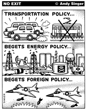
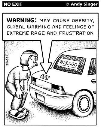
In subtle yet cumulatively significant ways, extra driving adds to the burden of death, injury and disease. Car accidents, obesity and physical inactivity, exposure to air pollution, and reduced opportunity for neighborly interactions can all result. And all these things take a toll on our health.
…mile for mile, riding a bus is more than ten times safer than driving a car.
…vehicle-related fees–fuel taxes, license and registration fees, and the like–cover only part of the costs of roads, bridges, public parking spaces, and other public expenses of driving. Taxpayers, even those who drive little, pick up the rest of the tab. If drivers had to pay the full costs for owning and operating their automobiles, they would pay more to drive–and, as a consequence, they would be less inclined to choose places to live where destinations are far apart and where driving is a necessity for every trip.
Not so fast! It’s difficult for folks to afford to live in this region, suburbs or not, but Seattle is one of the few cities in the country where it is possible to get a location-efficient mortgage (LEM). If you buy in a community that provides strong alternative transportation options, the money you will save on commuting is counted as income, and you can qualify for a larger mortgage than you otherwise would have.
On a related note, I found this on Detroit’s Transportation Riders United Web site:
Common mortgage-lending practices make urban living artificially unaffordable. Most homeowners devote about 55 percent of their income to housing and transportation costs combined. Families in suburban areas spend 30 percent on their homes and 25 percent or more on their cars. Those in urban neighborhoods with good transit spend a mere 10 percent getting around but 45 percent on their homes.
But mortgage bankers rarely allow housing payments to exceed 30 percent of income, so urban abodes are “mortgage unaffordable” for many buyers. The mortgage industry’s view steers buyers to the suburbs, indirectly increasing air pollution, traffic, and sprawl.
Patrick H. Hare