Category Archives: transit technology

And one more…

This one’s for transit-geek types:

Transit Applications and Data Workshop

What: A workshop for developers who make (or want to make) software applications using Metro’s data.

Do you develop applications using transit data, or are you interested in doing so? Come to a free workshop hosted by King County Metro Transit and tell us how we can partner with you to make it easier. The event will include a panel discussion, an opportunity for participants to demonstrate their applications, a breakout session for exploring specific topics such as data feeds, real-time information, and upcoming updates in Metro technology.

When: Thursday, October 22nd, 4 PM – 7 PM
Where: King Street Center
How much: Free! (Registration is required.)

This is goodness. I am glad to see Metro taking advantage of our significant local brain resources. Partnering, educating, and providing easier access to data will only benefit the agency (and all of us).

P.S. – Bus Nerd (my favorite local brain resource) is planning to attend. :)

House hunting, bus chick style

For several weeks now, I’ve been meaning to tell you about Estately.com, also known as the coolest real estate website on the internets. In addition to the standard stuff (price, square footage, number of bedrooms, type of property, etc.), it lets you base a home search on proximity to transit (!) and/or a neighborhood’s walkability. So, for example, a person could search for homes under 500k, within a quarter mile of a 27 stop (yes, you can filter by specific bus routes), in a neighborhood with a walk score between 80 and 100.

This is brilliant–and something I’ve been dreaming of for a long time. I think I’ve mentioned that where a person lives is the single most important factor in determining her happiness and success as a car-free type. And until now, finding a car-free-friendly (car hostile?) neighborhood has required a fair amount of research–especially for folks who are not familiar with the area. Estately doesn’t eliminate the need to research the neighborhoods you’re considering moving to, but it certainly helps to narrow the field.

Plus, it’s pretty addictive. I’ve been playing with it all evening–looking for homes that are near Link, near at least two bus lines, in neighborhoods with walk scores over 90… I think I might have to move just so I can take advantage of it.

For now, Estately.com serves all the major markets on the West Coast, Chicago, New York, and Atlanta. (More cities to come!) They don’t have plans to create a similar service for renters (I imagine it would be hard to fund and possibly to manage), but I’ll keep my eyes open.

Catching up

After 21 post-free days–the longest hiatus I’ve taken from this blog in the three (plus) years I’ve been writing it–I return (project: complete, Chicklet: healthy and enjoying her bus rides more than ever), determined to reestablish a more regular posting schedule in May.

I’ve had about a zillion bus adventures since I last checked in–far too many to write about. The good news is, there will be many zillions more.

On to the transit news of note:

I trust you all noticed that Metro’s website has new and improved home page. It’s the beginning of a long-overdue update/upgrade to make the site more relevant, responsive, and usable. Some highlights: Trip Planner entry fields are now on the home page (not three clicks away); the navigation is simpler; and there are “quick” links to important stuff like Orca information and Tracker. It ain’t perfect (yet), but it’s a good start.

The Orca payment system is live. As it happens, my annual pass expired on May 1st, so I’m now using an Orca card. This month, I’m trying the “e-purse” only, which means that I didn’t purchase a pass; the money I loaded onto the card is deducted as I ride. Since I’m not commuting five days a week anymore, and, since, with Orca, paying cash is as convenient as paying with a pass (more on that later), I figured it was worth it to find out how much money a pass actually saves me.

I had a few glitches at first–it took a couple of days for the money I added online to register in the system, and a couple more days for transfers to work correctly–but everything seems to working fine now.

What I love:

• You don’t have to buy a pass to have the convenience of a pass. If you’re an infrequent rider, you can add money to your e-purse and use your card when you need it. No more worrying about having correct change or keeping track of transfers.
• If you do buy a pass, you can add extra money to your e-purse for trips that exceed the pass’s value. Beautiful!

What I don’t love:

• Annual passes are no longer an option. I have no idea why.
• Orca’s web interface for loading money and buying passes–especially for people with new cards–is confusing. It’s not clear up front how to buy a pass, and it’s also not clear if you can use the money you load into your e-purse to purchase a pass (you can’t).

On the whole, though, I’m loving the change.

Anyone else have thoughts about Orca–or, for that matter, Metro’s new home page?

* This includes, believe it or not, the period after my mother’s death and the period after Chicklet’s birth.

Bus wireless, circa 2005

I’m at the Renton Transit Center, on the 106, waiting to pull out and head back to Seattle. Which reminds me, I rode a brand, spanking new 101 down here: a new style of seats, a new style of straps, and clea-ean. I took a pretty bad photo of the seats on my way out, which I might post later. I digress.

I’m running out of time to tell you that my beloved (and somewhat beleaguered) laptop just connected to somebody’s unsecured network long enough for me to check my Facebook feed (yes, I have an addiction) and my e-mail. Back when unsecured networks were the norm, Nerd and I used to jump on them at lights and stops almost every time we rode the 48. Ah, those were the days!

(Update, 3/3: Here’s my (blurry) photo of the seats.)

Transportation in the news

DC Metro refuses to share data with Google

Three years after the launch of Google Transit, which gives directions using transit on Google Maps, and after constant requests by riders and bloggers, WMATA’s Director of Customer Service, Brett Tyler, announced their decision that participating in Google Transit is “not in our best interest from a business perspective.”

(Source: Greater Greater Washington, via Streetsblog)

Link found between “active transportation” and lean population

New research illustrates the health benefits of regular biking, walking or taking public transportation to work, school or shopping. Researchers found a link between “active transportation” and less obesity in 17 industrialized countries across Europe, North America and Australia.

[…]

Americans, with the highest rate of obesity, were the least likely to walk, cycle or take mass transit … The authors say it’s more than lifestyle choices that lead Americans to use their cars more. [Can you say “carism”?] Europe’s compact, dense layout and infrastructure are more conducive to getting around without a car.

(Source: MSNBC)

More people in NYC, but not more traffic

As the city’s economy soared and its population grew from 2003 through 2007, something unusual was happening on the streets and in the subway tunnels.

All those tens of thousands of new jobs and residents meant that more people were moving around the city, going to work, going shopping, visiting friends. And yet, according to a new city study, the volume of traffic on the streets and highways remained largely unchanged, in fact declining slightly. Instead, virtually the entire increase in New Yorkers’ means of transportation during those robust years occurred in mass transit, with a surge in subway, bus and commuter rail riders.

(Source: NYT)

Another cool bus tool

A couple of months back, Ron from Queen Anne (a fellow 3/4 rider and fan of Smooth Jazz) sent me a link to a website that I’ve just gotten around to checking out. (So far, I’ve only had time for a cursory evaluation, so all of my observations should be considered with that in mind.) The site’s called One Bus Away, and it’s basically MyBus with a few improvements:

• Arrival info for every bus stop, not just a few timepoints.
• A telephone number you can call to quickly get real-time arrival info when you’re waiting at your stop.
• An updated website that makes it easier to find arrival info when you’re waiting at home.
• Enhanced mobile tools for iPhones, text-messaging and other mobile devices.

The phone number is useful for those of us who don’t walk around with our faces in PDAs (a la Bus Nerd) and are too cheap to pay for Internet service on our phones. The system works like Metro’s automated schedule information line, except it provides–hallelujah!– real-time information. Like Metro’s schedule line, it helps you identify your stop number if you don’t know it, but the process is necessarily tedious. It works best for stops you use often enough to memorize the number.

One Bus Away’s other claim to fame is the fact that it provides information for every stop in Metro’s system. This is definitely cool. As for the other stuff:

I’m not sure how the SMS option differs from the one MyBus offers–MyBus’s query actually seems easier to type–and while the website may be easier to use than MyBus, I wouldn’t call it easy. (To be fair, the person who created this site is a grad student donating his time, and–as Bus Nerd can attest–Metro doesn’t expose its data in the most bus-tool-developer-friendly manner.)

Bottom line: One Bus Away is worth checking out. Thanks for the tip, Ron!

An update on those bus wireless issues

Despite the fact that I’m kind of done talking about bus hackers (ST is aware of–and hopefully working on–the problem, after all) Bus Nerd is making me post this:

A compromised wireless network on the 545

It’s a screen shot of his network connection dialog during a recent ride on the 545. (This time it was coach 9539.) All told, he’s experienced this issue three times in the past few weeks. Just so you know.

Your bus is pwned

A warning for bus wireless users: Bus Nerd suspects a hacker.

This morning I was on the 545 (coach 9549) that left Montlake around 9:30 (yes, thanks to the 48 I was running late). When I tried to connect my laptop to the coach’s wireless Internet connection, I saw an unsecured network, identified as “bus_pwnage,” in the wireless network list.

Translation of “pwn” from hacker-speak (leet-speak) is “own,” the concept of “owning” a victim’s laptop, web site, etc. by hacking it. The bus has likely been pwned by some hacker (h4x0r). [This means that] a connected user might try to visit seattlepi.com, but the compromised bus could redirect her to a hacker site that hands control of the machine to the attacker.

Note that a suggestive network identifier is not definitive proof of breached security, but a hack is the simplest explanation for what I observed. Other supporting evidence: The signal strength for “bus_pwnage” was a constant 100% the entire ride, meaning the originator was travelling with the coach, consistent with the normal bus wireless scenario.

Picture
Bus Nerd’s visual aid

How could this happen? Presumably some bus rider with a laptop + skills + nothing better to do exploited a vulnerability in the access point that ST uses to provide wireless Internet access on the bus. The attacker gains control of the access point and, among many resulting powers, she could change the name of the network from something like “Sound Transit” to “bus_pwnage” to announce to the world (well, maybe just the passengers) her defeat of the oppressive regime of Sound Transit. Such a feat isn’t that hard since IT security professionals consider unsecure wireless networks (the kinds found in cafés and yes, public busses) to be as safe as Clay Bennett at Seattle Center. [You had to go there?]

If this was indeed a hack, is the vulnerability limited to just this vehicle? That’s better than a fleet of vulnerable coaches. I let the driver know what I saw, and he seemed hep to the danger and indicated he’d take some (unspecified) action.

As for the alleged bus hacker, will she / he be satisfied with coach 9549, or will she tag every bus ST wireless-enabled bus? Is this a vanity vandalism ploy, or a real threat to bus riders’ computer security? And think of the pandemonium that would ensue if hacked wireless were the jumping-off point to taking over a coach’s external route display – 43’s that advertised themselves as 48’s and other such tricks would be the bus apocalypse.

My guess is it’s just vandalism (for now). I like bus wireless, so I hope ST can demonstrate that my incident was actually benign or let us know they’ve taken steps to prevent intrusions. Until then, bus web-surfers must watch for sharks…

I don’t know, I’m kind of digging the idea of changing (and not just the numbers on the front) some of those ubiquitous 43s to 48s.

Good lookin’ out, Bus Nerd.

Transit envy

Last Friday, Bus Nerd, Chicklet, and I headed to Portland (on the train!) to participate in the Towards Carfree Cities conference. (Actually, I was going to participate in the conference, and Nerd and Chicklet were going to hang around Portland. Minor detail.) It turned out to be a bad day to attend the conference (most of the good events happened earlier in the week) but a good day to learn more about getting around Portland. (Disclaimer: I can count on two hands the number of times I’ve been to Portland–and on one hand the number of times I’ve been as an adult. Forgive me if this is old news to you Oregonphiles.)

I’ve been known to roll my eyes when folks start going on about how fabulously bikeable, walkable, and transit-friendly Portland is. It’s not that I don’t believe it; it’s just that I’m a bit of a Seattle partisan, and all that Portland love brings out the hater in me. Mostly, though, it makes me wish that my beloved hometown had grown smarter, with transit and biking as a focus, instead of ballooning into such a bloated, sprawling mess. But I digress.

I have to give credit where credit is due, and Portland deserves some credit for thinking outside the car. For starters, their train station is actually clean and inviting. (When is King Street’s interminable “remodel” going to be finished, anyway?) And, of course, there’s the bike thing. I could tell almost immediately that Portland is much more bikeable than Seattle (bike paths, bike parking, and bike nerds everywhere!), but I didn’t try to get around by bike while I was there (hey, I know my limits), so I can’t really speak about it.

Portland's train station
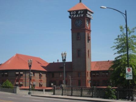
Portland’s train station (the inside ain’t half bad, either)
Picture
Bike parking at Powell’s

On to transit:

I’m extremely impressed by what Portland has going on. Though I was only there for one day, and I didn’t really venture beyond the downtown/waterfront area, I can say with confidence that Portland’s system (TriMet) is much more usable (and useful) than Seattle’s. Some reasons why:

The website! I could write an entire post just about this. It is clearly organized, with easy access to the information riders need (trip planner, how to ride, maps, etc.). To find out how to get to the conference location, I typed “Amtrak Station” and “Portland State University” into the trip planner entry fields on the home page and (immediately, without errors or a list of obscure locations I might have meant to enter) got several useful itineraries, complete with fare information, links to maps, and detailed information about the stops, including the stop IDs. All transit websites should be this good.

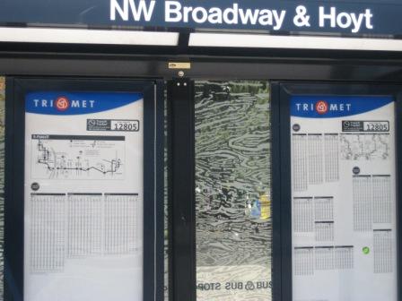
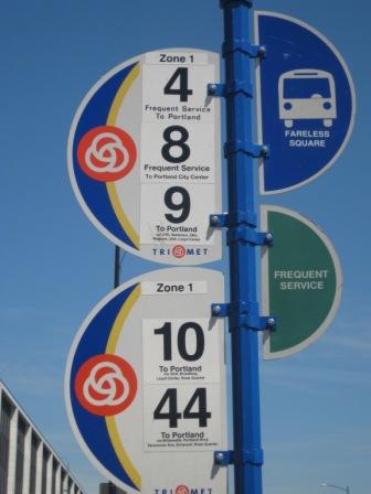
• The bus stops. At the big stops, the shelters tell you the intersection where the stop is located, so you don’t have to walk to the corner and try to read the signs. The signs tell you: the stop ID (which, unlike in Seattle, you can use for TriMet’s version of Tracker or the automated phone system), if you’re in the Fareless Square, and if the stop has frequent service.

A Portland bus shelter
A Portland bus stop

• The streetcar. Getting around the center city on that thing is a cinch. Since it’s a fixed route and there are maps available almost everywhere, you can (and we did) use it to get from the waterfront to PSU to Powell’s without knowing a single thing about Portland or its transit system. No asking the driver of whatever route happens to show up, “How far do you go down 3rd?” No hassles trying to figure out how to get from one corner of downtown to another without a long, uphill walk (favored by bus chicks but few others), a transfer, or a cab ride.

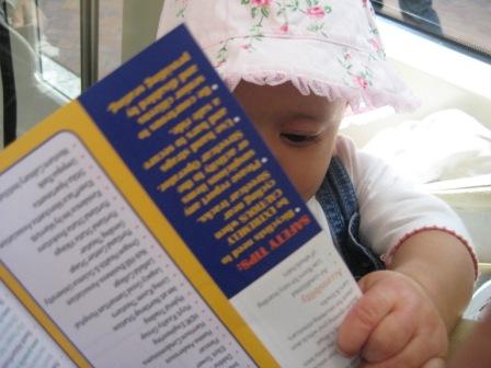
(Note: I might get my bus chick credentials revoked when I admit that I haven’t yet ridden the SLUT, but there it is. Yes, Chicklet keeps me pretty busy, and blah, blah, blah, but the truth is, it doesn’t go anywhere I need to be–or, at least, it doesn’t go anywhere I’ve needed to be since it began operating. I’ll check it out before the summer’s over, but to clarify: This is not a comparison of Portland’s streetcar and Seattle’s [except perhaps to suggest that Portland’s is more useful to a larger number of people] but rather, a comparison of how easy it is to get around the cities’ downtown areas.)

Chicklet learning about the Portland streetcar
Portland Streetcar: So easy, a baby could ride.

• Digital signs inside vehicles. We saw these on the streetcar and on buses. They are very helpful if you don’t know a city (and don’t have a husband who uses a personal GPS device with his nerd phone), are in an unfamiliar neighborhood, or can’t see out the window.
MAX light rail. I didn’t ride it, but it’s there. Enough said.

Other stuff of note:

• The streetcar had audio ads over the automated PA. They went something like this: “State street station, brought to you by the State Street Grill.” It was kind of creepy, but interesting nonetheless; I’m always keeping my eyes out for new ways to fund transit. Most of the ads I heard were for new condo developments. And speaking of…

A condo ad on the Portland Streetcar
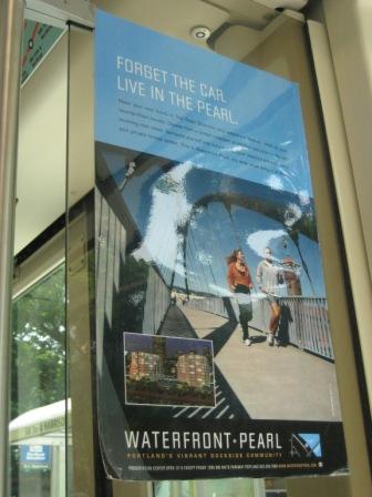
“Forget the car. Live in the Pearl.”

• We ran into Vic and Julia from Sustainable Ballard/Undriving Ballard (he-ey, ladies!) on the streetcar. They were in town for the conference as well. Julia even presented earlier in the week.

Portland isn’t perfect, by any stretch. Like most (OK, all) US cities, it still feels very car-dominated. I’m also aware that, despite their proximity, Seattle and Portland are very different cities–in part because of differences in size and geography, and in part because of better planning on Portland’s part. Still, what I wouldn’t give to have a little of what they’ve got around here. How about we start with a new and improved website?