
Watch this:
Category Archives: multi-modal
Transit envy
Last Friday, Bus Nerd, Chicklet, and I headed to Portland (on the train!) to participate in the Towards Carfree Cities conference. (Actually, I was going to participate in the conference, and Nerd and Chicklet were going to hang around Portland. Minor detail.) It turned out to be a bad day to attend the conference (most of the good events happened earlier in the week) but a good day to learn more about getting around Portland. (Disclaimer: I can count on two hands the number of times I’ve been to Portland–and on one hand the number of times I’ve been as an adult. Forgive me if this is old news to you Oregonphiles.)
I’ve been known to roll my eyes when folks start going on about how fabulously bikeable, walkable, and transit-friendly Portland is. It’s not that I don’t believe it; it’s just that I’m a bit of a Seattle partisan, and all that Portland love brings out the hater in me. Mostly, though, it makes me wish that my beloved hometown had grown smarter, with transit and biking as a focus, instead of ballooning into such a bloated, sprawling mess. But I digress.
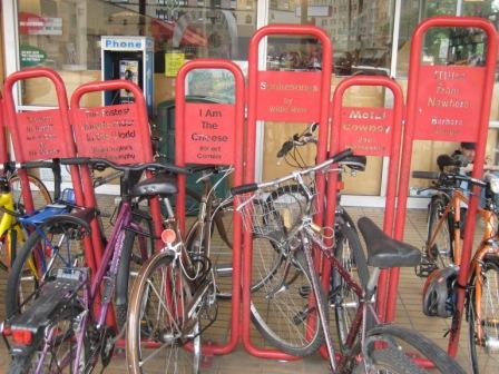
I have to give credit where credit is due, and Portland deserves some credit for thinking outside the car. For starters, their train station is actually clean and inviting. (When is King Street’s interminable “remodel” going to be finished, anyway?) And, of course, there’s the bike thing. I could tell almost immediately that Portland is much more bikeable than Seattle (bike paths, bike parking, and bike nerds everywhere!), but I didn’t try to get around by bike while I was there (hey, I know my limits), so I can’t really speak about it.
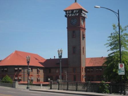
Portland’s train station (the inside ain’t half bad, either)
On to transit:
I’m extremely impressed by what Portland has going on. Though I was only there for one day, and I didn’t really venture beyond the downtown/waterfront area, I can say with confidence that Portland’s system (TriMet) is much more usable (and useful) than Seattle’s. Some reasons why:
• The website! I could write an entire post just about this. It is clearly organized, with easy access to the information riders need (trip planner, how to ride, maps, etc.). To find out how to get to the conference location, I typed “Amtrak Station” and “Portland State University” into the trip planner entry fields on the home page and (immediately, without errors or a list of obscure locations I might have meant to enter) got several useful itineraries, complete with fare information, links to maps, and detailed information about the stops, including the stop IDs. All transit websites should be this good.
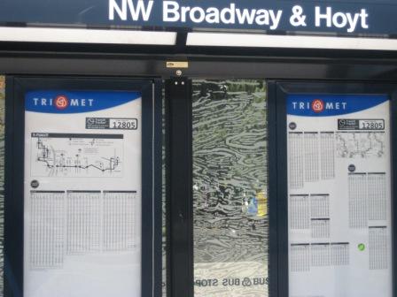
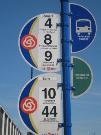
• The bus stops. At the big stops, the shelters tell you the intersection where the stop is located, so you don’t have to walk to the corner and try to read the signs. The signs tell you: the stop ID (which, unlike in Seattle, you can use for TriMet’s version of Tracker or the automated phone system), if you’re in the Fareless Square, and if the stop has frequent service.
• The streetcar. Getting around the center city on that thing is a cinch. Since it’s a fixed route and there are maps available almost everywhere, you can (and we did) use it to get from the waterfront to PSU to Powell’s without knowing a single thing about Portland or its transit system. No asking the driver of whatever route happens to show up, “How far do you go down 3rd?” No hassles trying to figure out how to get from one corner of downtown to another without a long, uphill walk (favored by bus chicks but few others), a transfer, or a cab ride.
(Note: I might get my bus chick credentials revoked when I admit that I haven’t yet ridden the SLUT, but there it is. Yes, Chicklet keeps me pretty busy, and blah, blah, blah, but the truth is, it doesn’t go anywhere I need to be–or, at least, it doesn’t go anywhere I’ve needed to be since it began operating. I’ll check it out before the summer’s over, but to clarify: This is not a comparison of Portland’s streetcar and Seattle’s [except perhaps to suggest that Portland’s is more useful to a larger number of people] but rather, a comparison of how easy it is to get around the cities’ downtown areas.)

Portland Streetcar: So easy, a baby could ride.
• Digital signs inside vehicles. We saw these on the streetcar and on buses. They are very helpful if you don’t know a city (and don’t have a husband who uses a personal GPS device with his nerd phone), are in an unfamiliar neighborhood, or can’t see out the window.
• MAX light rail. I didn’t ride it, but it’s there. Enough said.
Other stuff of note:
• The streetcar had audio ads over the automated PA. They went something like this: “State street station, brought to you by the State Street Grill.” It was kind of creepy, but interesting nonetheless; I’m always keeping my eyes out for new ways to fund transit. Most of the ads I heard were for new condo developments. And speaking of…
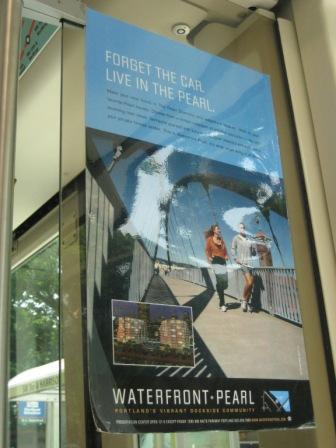
“Forget the car. Live in the Pearl.”
• We ran into Vic and Julia from Sustainable Ballard/Undriving Ballard (he-ey, ladies!) on the streetcar. They were in town for the conference as well. Julia even presented earlier in the week.
Portland isn’t perfect, by any stretch. Like most (OK, all) US cities, it still feels very car-dominated. I’m also aware that, despite their proximity, Seattle and Portland are very different cities–in part because of differences in size and geography, and in part because of better planning on Portland’s part. Still, what I wouldn’t give to have a little of what they’ve got around here. How about we start with a new and improved website?
More about walkability
 Last week I posted a link to walkscore.com, a website that calculates the walkability of a given address based on the number of stores and other amenities within–you guessed it!–walking distance. It’s a cool site (and probably accurate in most cases), but I’m hoping it will eventually evolve to something a bit more sophisticated. The thing is, walkability is about a lot more than how many stores are in your neighborhood. For me, it’s about the safety, convenience, and general pleasantness of actually getting to them.
My house, for instance, scored an 86. I’d give it about a 75. (Note that Bus Nerd would strongly disagree with me on this. He thinks walking around here is perfectly fine.) Much as I love being so close to a library, two community centers, two parks, lots of schools, and six bus routes(!), I do not love the narrow sidewalks, speeding cars, and pedestrian-unfriendly street crossings. There are several stores nearby, but they are almost all in strip malls, and to actually get to any of them, you have to cross huge parking lots (full of speeding cars).
Not that any of that stops me. I love walking. I walk to church, to the grocery store, to the beauty shop, to the coffee shop, to the park, to the pool, to the video store, to the drug store, and–at least a couple of times a month–all the way downtown. Truth be told, I prefer walking to riding the bus. If the weather was always nice and I had all the time in the world, I’d walk everywhere I needed to go–well, within five or so miles. (Once, I talked Bus Nerd into walking all the way to Pier 55 to catch the Water Taxi, and then from Seacrest Park, where the Water Taxi dropped us off, all the way to the end of Alki to meet my brother for lunch. Oh yeah, and then back.)
But enough about me already. What do you think makes a neighborhood walkable?
How walkable is your neighborhood?
Several people sent me links to this site (thanks Robert, Elisa, and Jennifer!), and Alan Durning blogged about it: walkscore.com, a cool web tool that calculates the walkability of any address in the US.
What is Walk Score? Walk Score helps people find walkable places to live. Walk Score calculates the walkability of an address by locating nearby stores, restaurants, schools, parks, etc.
My house (which is in the Central District) got an 86 out of 100. Not bad, though I might not score it quite so high. (The folks at walkscore.com haven’t tried to cross my very busy street without getting hit by a careless, speeding, light-running motorist.) My father-in-law, who still lives in Bus Nerd’s childhood home in Detroit, earned a decent score of 57. My best friend Laurie (mother of Zaky) got an abysmal 22. (At least they have free buses where she lives.) My brother Jeremy, the newly minted New Yorker is the hands-down winner with an impressive score of 98. (I wonder how you get 100?)
Your turn. What’s your walkability score?
Speaking of etiquette…
A multimodal bus foul:
Wiping the post-bike-to-the-bus-stop sweat from one’s brow with one’s bare hands and then repeatedly flinging said sweat toward the front of the bus, nearly missing several other passengers and the driver.
A good way to avoid committing this one: packing a towel or rag in one’s pannier/bus chick bag.
Bike to Work Day, busnerd-style
Bus Nerd, ready to ride:

I’m not riding this year, so he took my cool folding bike. Note the choice of t-shirt. I think he felt guilty for forsaking the bus.
What’s better than free food at a transit fest?
A few weeks ago, my employer sponsored Bus to Work Day at Overlake Transit Center. It was a fun Friday distraction, with representation from transit agencies and commute specialists, free food (including chocolate-chip cupcakes!), and a prize drawing. I entered the drawing and then promptly forgot about it–that is, until Wednesday, when I found out that I’d won a brand new, shiny, red folding bicycle.
One of the (many) reasons I rarely ride a bike is because there is no outdoor bike storage where I live. (The hand-me-down mountain bike that Bus Nerd hooked me up with is currently languishing in his office, awaiting a dusting off in time for Bike to Work Day. But I digress.) A folding bike is a perfect solution because I can store it inside–in a closet, or even under the bed.
The bike I won is a Dahon. I don’t know much about bike manufacturers, but so far, I like what I’ve seen on the company’s website:
Dahon was founded with the singular purpose of convincing more people to use environmentally-sustainable forms of transport. To accomplish this goal, we’ve focused on creating innovative but reasonably-priced folding bicycles.
[…]
Dahon is committed to creating green mobility solutions for people who live active, environmentally friendly lifestyles.
I also love the design. It’s compact and fairly simple to open and close.
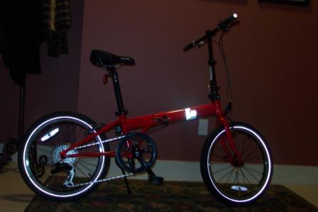
My new bike, open and ready to ride
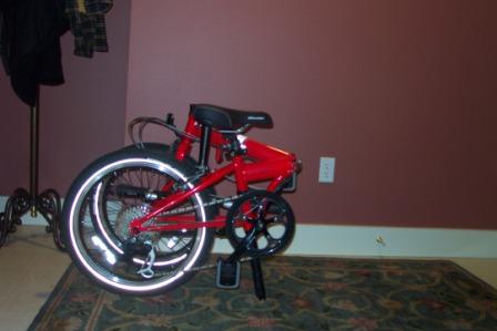
Less than a minute later: my new bike, folded and ready to store
Of course, I don’t know how it rides yet, having only tried for a couple of minutes in front of my office on Thursday afternoon, and I’m not sure how well it will work for multi-modal scenarios. When I tried to take it home from work (in its folded state) on Thursday, the 545 driver told me I couldn’t bring it on the bus. I didn’t have time to unfold it, and I wasn’t convinced that, given its small wheels, it would fit on the regular bike rack. Lord knows I wasn’t trying to experiment on a bus full of impatient commuters. He finally allowed me to store it under one of the lifting seats in the front. At Montlake, I was nervous getting on the 48, but that driver let me on without a word.
I’ve seen folded bikes on the bus before, but I don’t know what the official rule is, or even if there is one. Until I know for sure (or at least until I’ve had a chance to see if mine will fit on regular bike rack), I’ll keep it in the coat closet and use it for the trips I’ve been wanting a bike for: regular errands that are too far to walk in a reasonable amount of time but are inconvenient by bus. Oh yeah–and trips to Cupcake Royale.
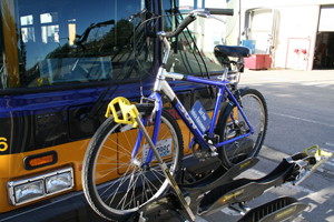
Good news for bike nerds
Three-bike racks!
From a Metro press release:
Currently, all Metro buses are equipped with two-bike racks, but that isn’t enough on some routes where bicyclists must wait for an open rack on the next bus. The addition of a three-bike rack has been long awaited by bicyclists, especially those who want to travel across the State Route 520 Bridge where there are no bike lanes. That is why the first of these racks are being installed on buses assigned to routes that travel between Seattle and the Eastside. …
The purchase and installation of the [three-bike] racks is being funded through a $195,000 federal grant, which should cover the cost at the first two bases. More racks will be installed on the rest of the fleet as funding becomes available, plus any new bus purchased in the future will come with a three-bike rack already installed.
Metro has installed the racks on nine buses so far (Bus Nerd’s already seen one), and they’ll be adding about 25 a week for the next 10 weeks.
I’m (still) not much of a biker, but I know a useful improvement when I see one. This is goodness–except maybe for the drivers, who’ll have to maneuver already enormous buses with those big ol’ contraptions on the front. And of course, we still need to find a safe, warm environment for folks to learn how to use ’em…
Montlake: a pedestrian’s nightmare
To get home from the Eastside in the evenings, I usually take the 545 to Montlake and then transfer to the 48. I say “usually” because sometimes I ride the 545 all the way downtown to transfer just to avoid the tedious and time-consuming trip from the bus stop on 520 (where I get off the 545) to the bus stop on Montlake Blvd. (where I catch the 48).
I am OK with walking all the way up a long hill from the freeway stop to Montlake and then down the block to the corner of Montlake & E. Lake Washington (see black line below), but what’s with the crosswalk situation? There is no crosswalk directly across the street to the southbound bus stop (green line), so I have to either:
• Cross three times–and wait for three separate lights (orange line), OR
• Walk down a few flights of stairs to the eastbound side of the 520 (see label), walk a block or so west, and then walk up a couple more flights of stairs to the west side of Montlake.
Neither option works well when one is in a hurry to catch the bus, and missing a forty-late can mean a 30-minute wait on an isolated island surrounded by cars. No likey.
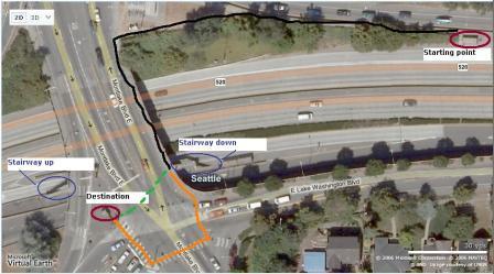
(Click the picture for a larger view.)
I was hoping that Greg Nickels would add this insane intersection to his list of streets that need improvements, but I think it will probably be left alone until we figure out what we’re going to do with 520. On the plus side: Stair climbing is good for your glutes.
Speaking of trains…
Erica Barnett’s been checking out the new rail line in Denver:
Here, in a city pretty much no one would regard as cutting-edge (the girls are still wearing tube-tops; the guys still favor large wire-framed Dick Cheney glasses), light rail has managed to take thousands of cars off the road. Surveys found that nearly 50% of light rail riders switched to transit from cars, and that more than 25% of commuters to the city center get there by transit. Light rail ridership here has been 60 percent higher than projections.
Thanks to Andrew from Sound Transit for sending the link.
Unfortunately, there won’t be any coming-out parties east of the mountains in the near future.
Light rail plans ran off-track Thursday evening when the Spokane Transit Authority disbanded the group charged with planning rapid transit between Liberty Lake and downtown Spokane.”
STA Board members unanimously voted to set aside the project, although they commended the Light Rail Steering Committee for its work.
Apparently, the board set aside $5 million for right-of-way purchase. I’m choosing to remain optimistic.